Metadata and database access instructions
Structure of the database
The database has 35 fields and 11,526 lines of data. An empty cell indicates that no information is available. Each line represents a single sighting of a turtle and may be one of four types of encounters. These four types are coded in the “Encounter code” field:
1 = Tagged by the JISTTP team in the Jupiter Island, Florida, study area
2 = Tagged by the JISTTP team outside Jupiter Island study area
3 = Reported on a nesting beach by other people
4 = Report of a tag recovery away from the nesting beach or a tag recovery from a stranded turtle
Patrol effort as described by Frank Lund
It is difficult to describe patrol effort or coverage in a short statement. It was an intense tagging effort in the sense that it was every night (we did not tag during thunderstorms!) from late May or first June until late August/ early September (we generally pulled off the beach after it was inundated by the first northeaster). The effective coverage across the length of the study area was quite variable, both within a season and across seasons due to the physical characteristics outlined below. The south 2 1/2 miles was the most the most thoroughly covered and was saturation-tagged in later years (many nights we hardly missed a nesting turtle). Saturation tagging was attempted across the entire study area, but a similar intensity could not be achieved due to the variable accessibility within the sea walled and vegetated beach zones.
Although our goal became saturation tagging during the later years, we honestly didn’t (and couldn’t) achieve it. We had set a goal to patrol so that we revisited any given spot every 35-40 minutes. We could, especially on the south end, cover it much faster, but felt that a greater frequency would just generate more false crawls. We had the resources; typically three tagging teams out each night (my team was 4-6 people/summer) with one team on south end, one in sea walls, and one on north end, but we soon learned that the physical impediments precluded achieving the time target or effectively consistent coverage. The sea-walled zone varied from no beach to intermittent beach to wide renourished beach. Even with pockets of good sand, outlying seawalls might be in the surf on some or all tides and block entry to the area. Passable entry could vanish in a week and reappear the next. Even a renourished beach might not be readily passable if under construction and blocked with equipment; the actual discharge pipe area was a formidable barrier (sand like quicksand and enough water flow to float a 3-wheeler off the beach).
For most years of our project, the north end Refuge beach had no high dune access route, and several stretches of beach were covered in stands of dead mangrove and Australian pines (as the dune rolled westward through the mangrove swamps) that were impenetrable even on a 3-wheeler during higher tides. It was a beach unlike anything I’ve seen on the east coast of Florida. Today, a combination of efforts by Refuge staff and storms have eliminated almost all the dead forest.
In addition to the physical challenges, coverage varied because of the fact that we began the project using jeeps to patrol (which really needed two people) then switched to faster more efficient solo 3-wheelers when they became available (which could better access refuge and seawalls, and then later shifted to 4-wheeled ATVs when they came on the market. It was only in the later years with the ATVs that we even considered trying to achieve saturation tagging. In the later years there is variability in the numbers of turtles tagged; some slight part of that is perhaps varying numbers of turtles, but a far greater influence was the changing ability to access the more challenging portions of the beach. The coverage in the middle seawall area and north end was highly variable depending upon physical ability to access the areas. It was not effective saturation tagging as was done on the south zone. The south beach was wholly passable except in severe storms. It was by far the best nesting beach on the island. Our cottage was in the middle of the section, directly on the beach, and it was run with far greater consistency than anywhere else.
One reason Dr. Labisky [Frank Lund’s major professor for his MS degree at the University of Florida] wanted us to continue for those last two years was to try to have a more consistent effort across the entire study area. By then we had nourished beach, better Refuge access, and better machines, so the coverage in those last 2 years was the most consistent, but still never with equal success across all three zones.
Tagging
Turtles were tagged with monel metal tags (size 49, National Band and Tag Company (NBTC), Newport, Kentucky) initially supplied by Archie Carr at the University of Florida (A and AA tag series). The tags were inscribed with an identification number, an offer of a reward for the return of the tag, and the University of Florida return address. Beginning in 1971, Frank Lund purchased the same style tags from NBTC (JI series). These tags had a return address of “Reward Return, Frank Lund, Box 541, Jupiter FL.” The standard $5.00 reward was paid for each tag returned. Most turtles were tagged with a single tag on the trailing edge of the right front flipper close to the proximal end of the flipper.
Body size
Minimum straight-line carapace length, from the middle of the nuchal scute to the pygal notch, was measured with calipers to the nearest cm. Maximum straight-line carapace width was measured to the nearest cm with calipers at the widest part of the carapace. For a few turtles in 1972 through 1974, curved measurements were measured in inches with a tape measure (e.g., “39 inches CCL, 28 inches CCW”). We left these values in the Notes field without converting them. Measurements recorded by other researchers (Encounter Code not #1 or #2) may have used different measuring methods. For example, carapace length may be curved; if information was provided, we recorded it in the Notes field.
Nesting
Whether the turtle did or did not deposit eggs was noted for almost every turtle observed by the JISTTP team in the “Outcome of crawl” column.
Jupiter Island Beach Sections
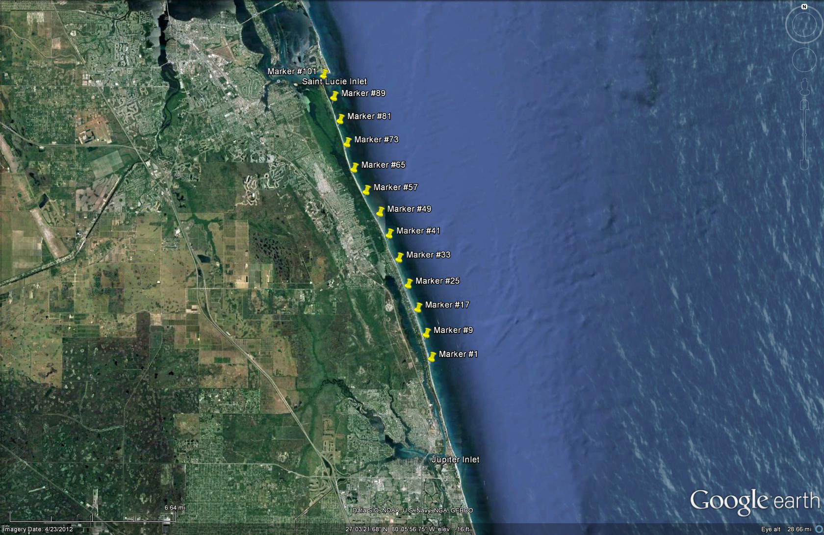
St. Lucie Inlet separates Hutchinson Island to the north from Jupiter Island to the south. Jupiter Inlet separates Jupiter Island to the north from Jupiter Beach Park and Juno Beach to the south. The Jupiter Island beach sections (#0-101) were 0.125-mile sections (map). Marker #1 was 12.6 miles south of St. Lucie Inlet. Turtle location is assigned to the section marker to the south; that is, Section #1 is north of Marker #1. Section 0 was the area of approximately 500 feet from Marker #1 south to Big Blowing Rocks. See the Jupiter Island map for locations of the section markers.
Tag series used by the JISTTP
- A413-425
- A701-850
- A901-1400
- AA901-1000
- JI001-6400
All other tags listed in the JISTTP database were applied by researchers on other nesting beaches in the southeastern US.
Definitions of data fields
- Master Tag: This tag number is the identification number that links all records for an individual turtle, even if the tag numbers change.
- Previous Tag 1: Tag number already on turtle when first seen by JISTTP team.
- Previous Tag 2: 2nd tag number already on turtle when first seen by JISTTP team.
- Original Tag: Tag number placed on the turtle by JISTTP team; usually the same as the master tag.
- Duplicate Tag 1: Tag number applied by JISTTP team at the same time as the Original Tag.
- Duplicate Tag 2: 2nd tag number applied by JISTTP team at the same time as the Original Tag.
- Tag added elsewhere: Tag number added by another tagging program after turtle had been tagged by JISTTP team.
- Replacement Tag 1: Tag number added to a turtle by the JISTTP team that arrived already carrying a JISTTP tag.
- Replacement Tag 2: 2nd tag number added to a turtle by the JISTTP that arrived already carrying a JISTTP tag.
- Species: CC is Caretta caretta, CM is Chelonia mydas, DC is Dermochelys coriacea, EI is Eretmochelys imbricata
- Sex: All tagged turtles were females
- Outcome of crawl: NST = nest, FC = false crawl, or non-nesting emergence, FCD = false crawl, or non-nesting emergence, caused by known disturbance
- Beach section: Numbers 0-101 are for sections on Jupiter Island. For most turtles with a blank field, the location is described in the Notes field.
- Capture date: The date refers to the date that nightly patrols began. Thus, turtles tagged after midnight are assigned to the date of the previous day when the patrol began.
- Time: Time that the turtle was encountered. Time is recorded using 12-hour clock. All times < 8:00 are a.m., and all times >9:00 are p.m.
- Carapace length (cm): Minimum straight-line carapace length, measured from the middle of the nuchal scute to the pygal notch, with calipers to the nearest cm. Between 1972 and 1974, minimum curved carapace length was measured with a tape measure to the nearest inch for a few turtles when calipers were not available; these measurements are given in the Notes column.
- Carapace width (cm): Maximum straight-line carapace width was measured to the nearest cm with calipers at the widest part of the carapace. Between 1972 and 1974, maximum curved carapace width was measured with a tape measure to the nearest inch for a few turtles when calipers were not available; these measurements are given in the Notes column.
- Sea: Sea state: R = rough, S = smooth, C = choppy
- Sky: C = clear, O = overcast, R = rain
- Wind strength: C = calm, M = moderate, S = strong
- Wind direction: as determined by compass, e.g. ESE, WNW, NE, SE
- Tide phase: 1 = 1/4, 2 = 2/4, 3 = 3/4, 4 = 4/4 or full
- Tide: E = ebb tide, F = flood tide
- Moon phase: A = 1/4, B = 1/2, C = 3/4, D = Full, E = no moon
- Moon inclination: 1 = 9 o’clock, 6 = 3 o’clock
- Return: N = untagged or “new” turtle; R = return or tagged turtle.
R refers to both renesters within the same season and remigrants in later years. If a turtle with no tags was reported to have tag scars, it was coded as a return (R). If a turtle had been tagged earlier by another tagging program, it was coded as a return (R). - Tag scar: Y = scar present, N = no scar
- Retag: Y = new tag applied, N = no new tag applied
- Original tag removed: Y = yes, N = no
- Location of Injury: Each entry is coded as follows:
A = head
B = left anterior carapace quadrant
C = right anterior carapace quadrant
D = left posterior carapace quadrant
E = right posterior carapace quadrant
F = left rear flipper
G = right rear flipper
H = D + F
J = E + G
K = F + G
L = left front flipper
P = plastron
R = right front flipper
S = D + E
T = L + R - Severity of Injury: Each entry is coded as follows:
1 = ¼ of area lost
2 = ½ of area
3 = ¾ of area
4 = total lost - Age of Injury: F = fresh, O = old
- Type of Injury: Each entry is coded as follows:
B = broken from boat damage
C = cut off, missing
G = gash or notch
H = hole
M = mutilation.
S = split from boat damage - Encounter Code: Each entry is coded as follows:
1 = Tagged by the JISTTP team in Jupiter Island study area, Florida
2 = Tagged by the JISTTP team outside Jupiter Island study area, Florida
3 = Reported on a nesting beach by other people
4 = Report of a tag recovery away from the nesting beach or a tag recovery from a stranded turtle - Notes: Miscellaneous notes
Access to database
Access to the JISTTP database is available to everyone. To maintain a record of use, we ask that you send your request to Karen Bjorndal (Director, Archie Carr Center for Sea Turtle Research) at bjorndal@ufl.edu, and she will email you the database (~1200kb). The database is in MS Excel 2010 format. We would appreciate receiving notice of any use of these data (e.g., publications, presentations).
In any publication or presentation, please cite the database as follows:
Jupiter Island Sea Turtle Tagging Project (JISTTP). 2012. Archie Carr Center for Sea Turtle Research Legacy Database Initiative: http://accstr.ufl.edu/
For further information, please contact:
Archie Carr Center for Sea Turtle Research
PO Box 118525
University of Florida
Gainesville, Florida 32611 USA
Email: accstr@ufl.edu